
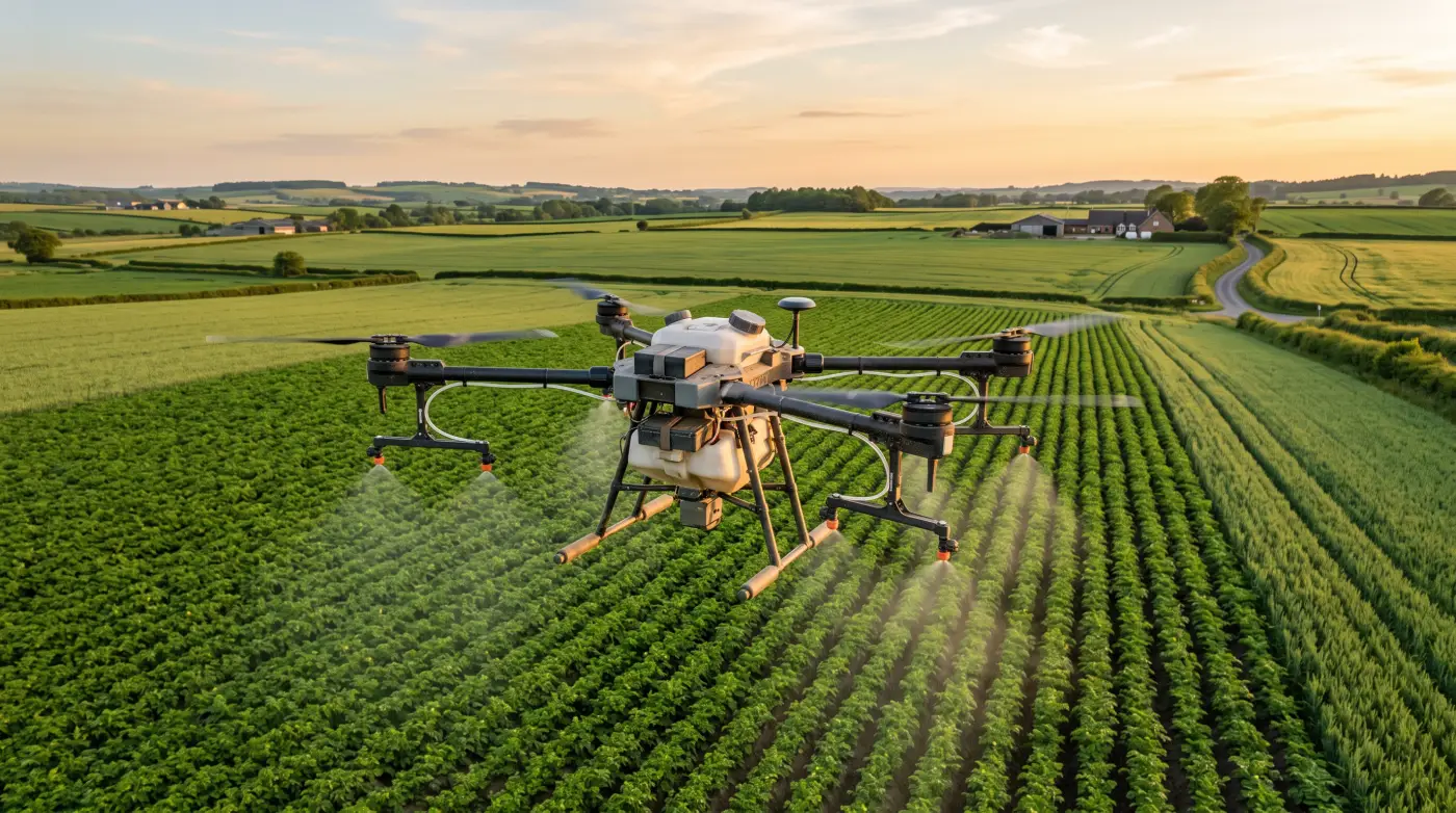
Drones in agriculture have moved from curiosity to tool in some situations, and still a poor fit in others. The difference comes down to how the drone is used, the regulatory burden, and the economics per acre. A drone can be a fast scouting tool and a useful way to verify a problem after a storm. It can also be a time sink if you expect it to replace a sprayer or a crop consultant. This article focuses on what is realistic looking toward 2026, especially for row crop operations.
Most farm drones fall into two categories. Imaging drones are small and built for mapping and scouting. Application drones are larger and designed to carry liquid or dry product for spot treatments. The skills, time, and maintenance requirements are different. Imaging drones are closer to a camera tool. Application drones are closer to a piece of application equipment.
Understanding the category matters because it drives cost per acre. A small imaging drone might cover a few hundred acres in a day with low operating cost, while an application drone might treat tens of acres per hour with higher operating cost and more regulatory requirements.
It also affects who uses the drone. Imaging drones are often run by a manager, agronomist, or scout. Application drones are often run by a trained operator who understands mixing, calibration, and drift. If you do not have the right person for the job, the technology will not pay back.
Multispectral imaging is another option in the imaging category. It can highlight stress patterns earlier than a standard RGB camera, but it adds cost and processing complexity. For many farms, a high quality RGB map is enough to see stand gaps and storm damage. Multispectral becomes more valuable when you are tracking in season stress or running trials.
In the United States, most commercial drone work requires a Part 107 remote pilot certificate. That includes farm use if you are flying for business purposes. Part 107 includes operational limits like flying below 400 feet above ground level, keeping the drone within visual line of sight, and not flying over people without a waiver. Night operations are allowed with proper training and lighting.
The certification is not hard, but it does require time to study and pass a test. The practical impact is that one person on the farm should own compliance and training. If nobody has the certificate, the drone will sit in a case during the season.
If you use a spray drone, you may also need to comply with pesticide rules and product labeling that applies to aerial application. That is a separate layer of regulation beyond FAA rules. It is worth checking with your state agriculture department before you apply product by drone.
Some operations also require waivers for certain activities such as flying at night or near people. Many of those waivers are now easier to obtain, but they still take time. If you expect to fly at dawn or dusk, plan that into your compliance work early.
Keep basic records. Log flight time, battery cycles, and any incidents. That helps with maintenance and also shows due diligence if you ever have a compliance question. A simple spreadsheet or logbook is enough.
The DJI Agras series is the most common name in agricultural spray drones in the United States. These drones are built to carry significant payloads and handle automated flight paths. They are also complex - they require calibration, battery management, and careful attention to wind and drift.
Application drones can be useful for spot spraying, especially in areas that are too wet for ground rigs or in fields with severe compaction risk. They are also useful for small specialty blocks where a full size sprayer is not efficient. They are less efficient for large, flat, broad acre fields where a high clearance sprayer can cover more acres per hour at a lower cost per acre.
A realistic way to think about application drones is to compare them to a small tender truck. They can be excellent for targeted work, but they are not a replacement for a 90 foot boom sprayer that can cover 600 to 1,000 acres in a day.
Calibration is critical. Spray drones typically use small nozzles and lower carrier volumes than ground rigs. That can work well for certain products, but it is not a universal fit. If a product label requires a high carrier volume or specific droplet size, a drone may not be the right tool.
Battery logistics are the hidden cost of drone operations. Imaging drones use small batteries and can charge quickly, but application drones rely on large battery packs that require careful handling and a charging plan. If you are spraying, you need a rotation of batteries, a generator or charging trailer, and enough water to mix product safely.
A common failure point is underestimating how long charging takes. If a battery takes 20 to 30 minutes to recharge and you only have two packs, your work rate drops fast. Most successful operators have enough batteries to keep the drone in the air while another pack is charging.
Field workflow matters. You need a safe launch and landing area, a clear mixing zone, and a plan for battery transport. If those pieces are not in place, the drone will spend more time on the ground than in the air.
Many operators build a small trailer setup with a generator, water tank, mixing table, and battery racks. That setup reduces downtime and keeps the work organized. Without it, batteries and product get scattered and efficiency drops.
Weather affects battery performance too. Cold mornings can reduce battery output and flight time, while hot afternoons can force longer cool down periods. If you plan to spray during a heat wave, build in extra battery capacity and time for cooling so you do not push packs beyond their safe range.
Drones can deliver very high resolution imagery - down to a few centimeters per pixel. That is useful for stand counts, emergence checks, and damage assessment after storms. The tradeoff is data volume and processing time. A 200 acre map at high resolution can create a very large file, and you will need a computer or cloud service to stitch it into an orthomosaic.
The practical approach is to balance resolution with purpose. If you are doing a stand count, fly low and accept longer processing time. If you are scouting for large scale damage, fly higher to cover more acres faster. Many operators end up with two standard flight plans - one for detailed scouting and one for broad coverage.
Processing speed also affects usefulness. If it takes two days to process a map, the data might be too late to act on. When evaluating software, pay attention to how fast you can get an actionable map, not just how pretty the final output looks.
If you need accurate measurements, consider ground control points. GCPs can improve absolute accuracy for mapping, which is useful when you are comparing drone data to planter passes or yield maps. They take extra time to set, but they can make the data more reliable for repeat monitoring.
Storage is another quiet cost. A season of high resolution maps can fill a hard drive quickly. Plan for a dedicated storage drive or a cloud account so the data do not end up scattered across random laptops. If you cannot find a map from last year, it is not helping you.
Decide what deliverable you actually need. Sometimes a stitched orthomosaic is enough. Other times you want a stand count layer or a vegetation index. Each extra product adds processing time and cost. If you only need to see gaps or storm damage, keep the workflow simple and focus on speed.
Thermal cameras can detect canopy temperature, which can be an early signal of water stress. That can help you identify irrigation issues or areas where the crop is struggling to keep cool. The key limitation is that thermal is sensitive to time of day and weather. Mid afternoon sun and low humidity can exaggerate stress, while a cloudy morning can hide it.
If you use thermal, fly at consistent times and compare relative differences within the same field. It is not a direct measurement of soil moisture, but it can highlight zones that deserve a closer look. Thermal maps are most useful when combined with soil moisture data or irrigation records.
Thermal also works best when the canopy is established. Early season bare soil can skew the signal. If your goal is irrigation scheduling, wait until the crop is covering most of the soil surface so the canopy temperature reflects plant stress rather than bare ground heat.
Imaging drones have a low variable cost per acre once you own the drone, but the labor cost can be significant. If it takes a half day to fly and process 500 acres, that is labor you need to account for. Many growers estimate $1 to $3 per acre in labor and processing, even if they do not assign a direct cash cost.
Application drones have higher variable cost per acre. Batteries wear out, nozzles need maintenance, and you must account for the product mix and refill time. Custom application rates by drone are often in the $8 to $25 per acre range depending on the job and region, which can be competitive for spot work but not for whole field applications.
The capital cost also matters. An imaging drone with a good camera might be $1,500 to $6,000. An application drone with batteries and a charger can be $20,000 to $40,000 or more. Those numbers vary widely, but they set the scale for ROI.
A simple ROI example helps. If a drone helps you catch a broken pivot nozzle and avoid a 10 acre yield loss at $250 per acre, that is $2,500 saved from a single flight. Those wins do not happen every day, but they are the kind of events that make drones pay back over time.
If you plan to use a drone for mapping every week, estimate the labor. One person flying and processing 400 acres might spend six to eight hours per week. At even $20 per hour, that is $120 to $160 per week. Over a 12 week season, that is $1,400 to $1,900 in labor, which should be part of your ROI math.
Safety is not optional. Drones may look small, but a heavy battery pack or a spray load can do real damage. Operators need a clear safety zone and a pre flight checklist. That includes propeller checks, battery inspections, and firmware updates. A small oversight can end a day of work or cause an accident.
Drift is a real issue for spray drones. Wind speed, droplet size, and boom height all matter. If you are applying herbicides, you need to follow label requirements and use drift reduction practices. If a drone application causes off target damage, the liability can exceed any savings from the technology.
Insurance is another detail. Some farm policies do not automatically cover drone operations. If you are flying regularly, ask your insurer whether you need a rider or separate coverage.
Personal safety matters too. Mixing and loading chemicals for a drone is still chemical handling. Use the same PPE and safe handling routines you use with ground rigs. The drone does not remove the need for basic safety.
Drones make sense when you need eyes quickly or when ground equipment cannot go. After a storm, a 20 minute flight can show lodging or hail damage without driving across the field. During wet seasons, drones can spot treat weeds or disease without rutting the field.
Drones also make sense for small blocks of specialty crops, seed production plots, or research trials where high resolution imagery is valuable. They make less sense when a pickup and a good scout can do the same job with less overhead.
Another strong use case is documentation. If you need to document storm damage for insurance, a dated aerial map is often more persuasive than ground photos alone.
Drones also shine in rugged terrain or terraced fields where ground equipment struggles. If a field is too steep or too wet for a sprayer, a drone can sometimes do the job with less risk of getting stuck or causing ruts.
They can also help with tile and drainage inspection. A quick flight after a heavy rain can show where water is backing up, which can save hours of walking. That kind of targeted scouting is a good example of how drones add value without replacing other tools.
Drones are not a good fit for large scale blanket spraying in broad acre row crops. A 120 foot ground sprayer can cover hundreds of acres per day with a lower cost per acre. Drones are also not a good fit if you do not have a trained operator or a clear workflow for processing imagery.
If the drone is going to sit on a shelf because the operator is too busy or the data are too hard to process, the investment will not pay back. It is better to rent or hire a service until you know you will use it consistently.
Another weak fit is when the farm does not have a clear data workflow. If you are not going to process maps within a day or two, the value drops sharply. In that case, a good crop scout or a truck with a tablet may be a better use of time.
Start with a clear goal. If you want stand counts, choose an imaging drone with a good RGB camera and mapping software. If you want water stress detection, add a thermal camera and plan for consistent flight times. If you want application, focus on regulatory compliance and safety first.
Then run a pilot on a small area. Fly the same field three times during a season and see if the data change your decisions. If it does, expand. If not, keep the drone as a scouting tool and avoid overinvesting.
If you do not have time to process data, consider hiring a service for the first season. That lets you learn what the outputs look like without carrying the full workload.
Budget time for training and maintenance. A drone is not a set it and forget it tool. You will need firmware updates, prop replacement, and periodic calibration. If you plan for that from the start, the drone will be reliable when you need it most.
It also helps to pick a dealer or service partner with parts on hand. If a prop breaks in July and you have to wait a week for shipping, the season will pass quickly. Local support is not flashy, but it is often the difference between a tool you use and a tool that sits on a shelf.
By 2026, drones will be common on farms that have a clear use case and a trained operator. They will not replace sprayers or crop consultants, but they can add speed and detail when used carefully. The most successful farms will treat drones like any other piece of equipment - they will use them when they fit the job and store them when they do not.
Imaging drones are small, camera-based tools for mapping, stand counts, and scouting, and a capable one costs roughly 1,500 to 6,000 dollars. Application drones are larger machines that carry liquid or dry product for spot treatments, and a full rig with batteries and charger runs 20,000 to 40,000 dollars or more. They demand different operators, maintenance, and regulatory compliance, so match the category to the job.
If you fly for business purposes, yes. A commercial Part 107 remote pilot certificate is required, and it caps operations below 400 feet above ground level, within visual line of sight, and off people without a waiver. The test takes study but is not hard. One person on the farm should own compliance and training, or the drone will sit in its case all season.
It depends on use. Imaging drones carry a low variable cost, roughly 1 to 3 dollars per acre in labor and processing, while custom drone application runs about 8 to 25 dollars per acre. The payoff often comes from single catches, like spotting a broken pivot nozzle before it costs a 10-acre yield loss worth 2,500 dollars. Consistent use and a real data workflow are what make them pencil.
Skip the drone for large-scale blanket spraying in broad-acre row crops, where a 120-foot ground rig covers 600 to 1,000 acres a day at a lower cost per acre. It also fails to pay back without a trained operator or a clear plan to process imagery within a day or two. If the drone will sit on a shelf, hire a service instead of buying.
Join our list for practical guides on farm tech, precision agriculture, and tools that work.